Conserving our Common Heritage: the role of spatial finance in the protection of World Heritage
Financial service providers can help prevent the exploitation of World Heritage Sites by using spatial analysis to gain a clear overview of economic activity in areas of global ecological significance.
World Heritage Sites (WHS) include some of the most remarkable and most important landscapes on earth, such as the Grand Canyon, the Great Barrier Reef and Okavango Delta. They have been internationally recognised as being of ‘Outstanding Universal Value’ and protected under the United Nations Educational, Scientific and Cultural Organization’s (UNESCO) World Heritage Convention.
Despite representing less than 1% of our planet, WHS are often threatened by potentially damaging commercial activities, such as mining, oil and gas extraction, hydropower plants, road construction, port development, deforestation, agricultural expansion or industrial fisheries.
A new joint report by WWF and Swiss Re Institute focuses on the concept of spatial finance in understanding threats to natural and mixed World Heritage Sites. Spatial finance is a new and emerging field which integrates geospatial data into financial theory and practice using GIS, remote sensing combined with machine learning. Spatial finance has the potential to transform the availability of independent information in our financial system to better measure and manage Environmental, Social and Governance (ESG) risk.
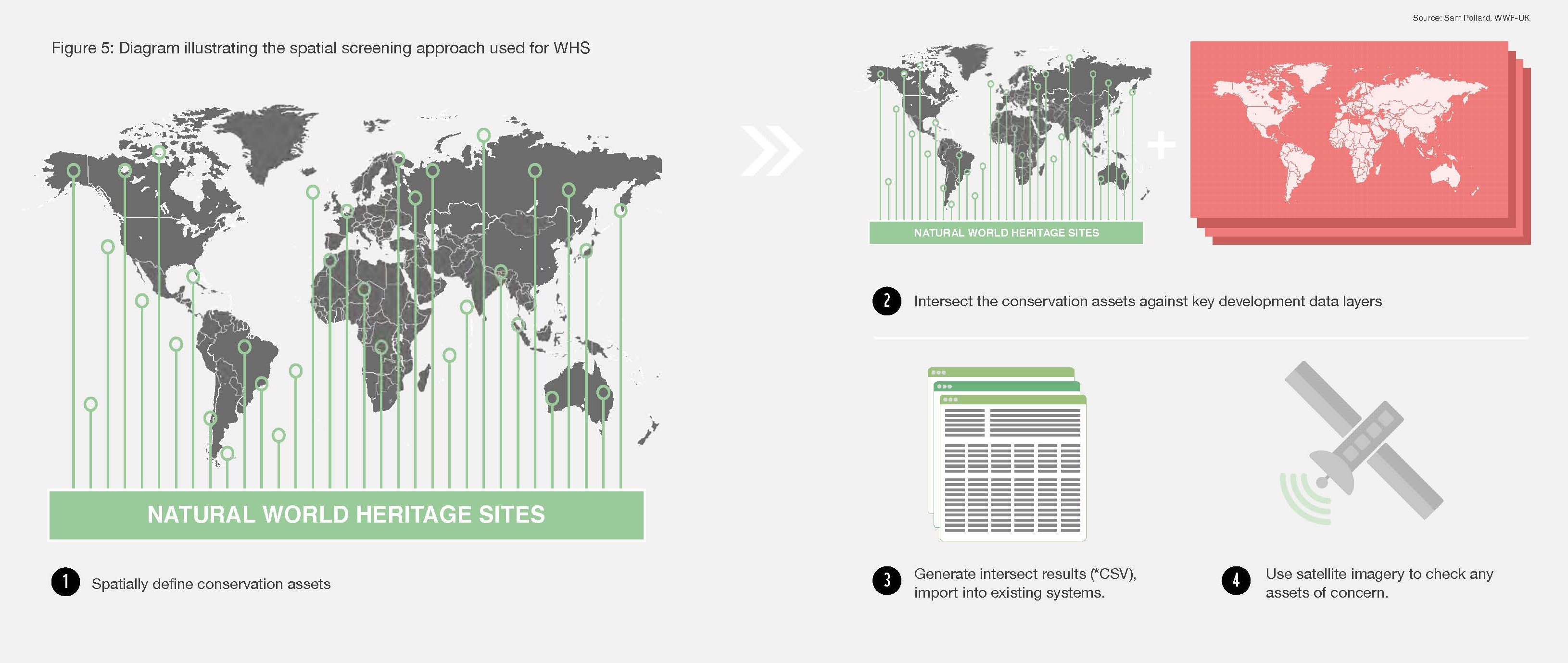
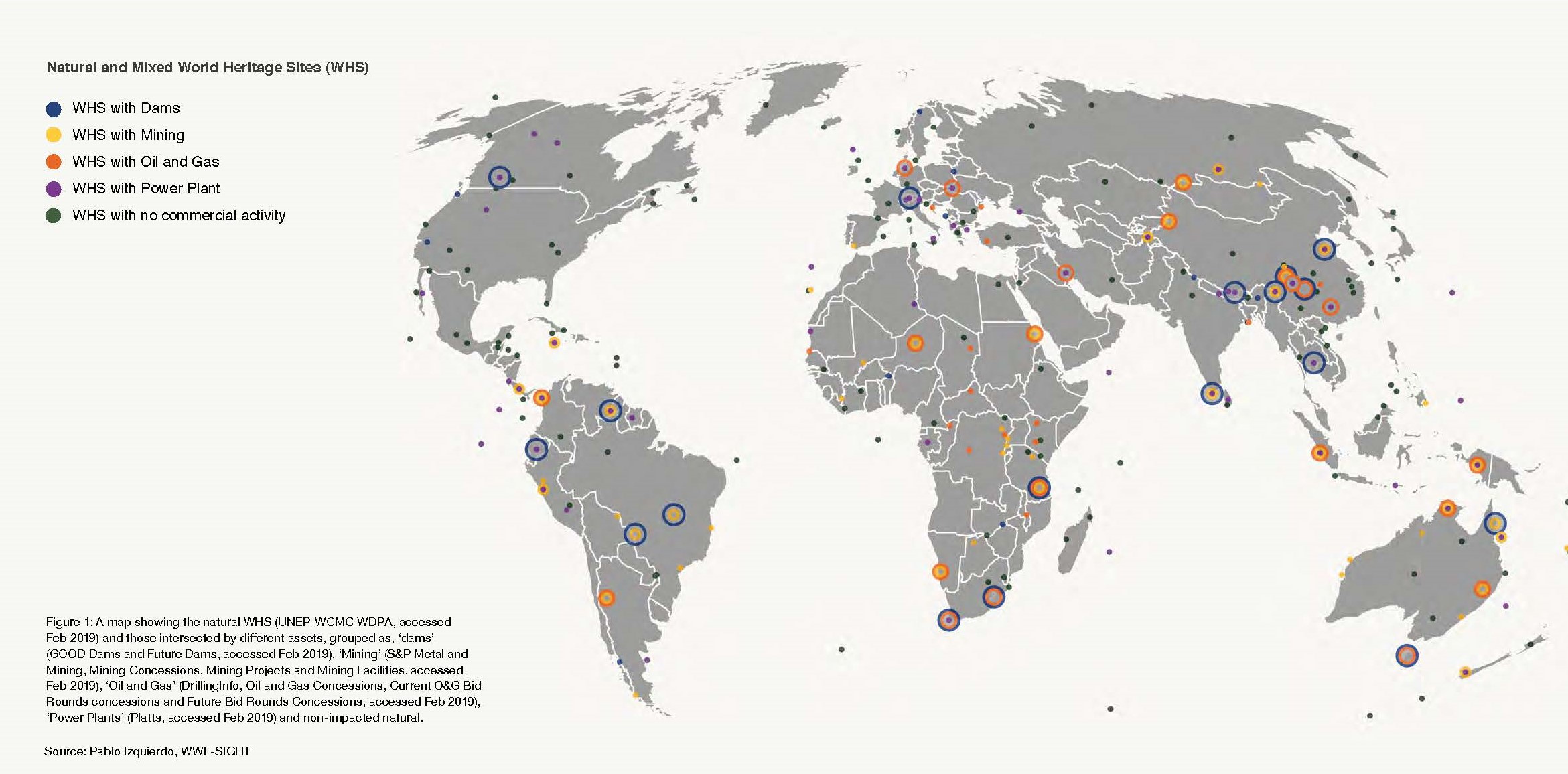
The report presents the latest, global geospatial analysis of key industrial threat to WHS, conducted by WWF. It shows that of the 244 sites (as of 2018) 119 natural WHS (48.8%), have been identified with one or multiple forms of potentially damaging commercial activity (extractives, power plants, and dams) within their boundaries. Of those 24% of WHS are overlapped with mining concessions, with 2% of sites having active mining operations within their boundaries; 16% are overlapped with oil and gas concessions and 23% had power plants located in WHS.
Almost all major forms of economic activity require financial services, be it investment, credit or re/insurance. This gives financial service providers (FSP) significant potential leverage over economic activities in WHS. At a time when shareholders and stakeholders demand higher transparency and accountability in FSP portfolio management the spatial finance approaches and geo-spatial analysis provide FSPs with systematic risk management and due diligence processes, identifying activities in WHS or other ecologically sensitive areas. Subsequent analysis can reveal who is undertaking the activity and allow this to be flagged in control systems.
Some financial service providers have committed to protecting the outstanding universal value of World Heritage Site, in particular leading insurers such as Swiss Re, who signed the UN Environment Programme’s Principles for Sustainable Insurance Initiative (PSI)/ WWF/ UNESCO commitment to protect World Heritage Sites, outlining key actions for the insurance industry as risk managers, insurers and investors. Spatial finance methods enable the systematic screening for industrial activities in WHS and thus allow responsible finance institutions to honour their commitments to protect World Heritage and other sensitive sites.
Despite the fact that spatial finance is still in its infancy, the field is rapidly evolving. The report has a number of recommendations for FSPs, but particularly highlights the important role of commercial financial data providers to:
- rapidly adopt spatial finance technology and techniques to improve the understanding of the impact of economic activity in and around WHS and other sensitive areas;
- acquire asset-level data for key sectors combined with key environmental, social and biodiversity spatial data and satellite imagery to be able to match ownership to the lending, investment and re/insurance portfolios of FSP.
Increasingly, FSPs will work these layers of data analyses into their risk management practices. Improved geolocation services will not only increase convenience, it will remove dependency on company disclosures and provide early warning of threats to Earth’s most special places.
Amandine Favier, Head of Sustainable Finance, WWF Switzerland
David Patterson, Head of Conservation Intelligence, WWF-UK
Susanne Schmitt, Nature and Spatial Finance Lead, WWF-UK
Oliver Schelske, Director Natural Assets Research and R&D Portfolio and Programme Management, Swiss Re Institute
Lasse Wallquist, Senior Sustainability Risk Manager, Swiss Re Risk Management